Showing posts with label Texas. Show all posts

Wednesday, January 09, 2008

Separation of Confusion and Bewilderment

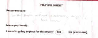
This was in my daughter's backpack, discovered as she cleaned it out in preparation for her return to school this morning:

prayersheet


When I asked where the sheet had come from, she replied that multiple copies of it had been passed out during lunch at school before winter break. When I asked who had passed them out, she said "adults" at school. I then asked her if they were adults she recognized from school (teachers, custodians, administrators, volunteers, etc) or strangers visiting. She told me that they were adults she saw regularly, and thought they were teachers though none she has for any subjects this year.

I'm a bit confused, only because our own family life is very categorized. "School things" happen at school, "church things" happen at church. My daughter attends public school, and does NOT belong to any religious youth groups that happen to meet on campus after school hours. I haven't found religious practice required in any of the curriculum requirements and standards for her grade either. And what is with the "I am also going to pray for this myself: yes, no?" Guilt much?

Explanations? Ideas?

Tuesday, November 20, 2007

Forecast

happyeskiimo
I'm so happy!!!!!

"SOUTHERN NEW MEXICO AND FAR WEST TEXAS WILL ENJOY NEAR RECORD
TEMPERATURES TODAY AND PLENTY OF SUNSHINE BOTH TODAY AND
WEDNESDAY. BUT LATE WEDNESDAY EVENING A STRONG COLD FRONT WILL
MOVE ACROSS THE REGION. HIGH TEMPERATURES ON THURSDAY WILL BE 15
TO 20 DEGREES COOLER THAN WEDNESDAY'S HIGHS. ALSO ON THURSDAY A
WEAK UPPER LEVEL STORM SYSTEM WILL BRING THE THREAT OF LOWLAND
RAIN SHOWERS NORTH OF LAS CRUCES AND SNOW SHOWERS IN AREA
MOUNTAINS. ON FRIDAY WE WILL CONTINUE WITH TEMPERATURES WELL
BELOW NORMAL. AGAIN THERE WILL BE A SLIGHT CHANCE FOR A RAIN OR
RAIN SNOW MIX IN THE LOWLANDS...WHILE AREA MOUNTAINS COULD SEE
SOME LIGHT SNOW. ON SATURDAY A SECOND STORM SYSTEM WILL TEAM UP
WITH A SECOND COLD FRONT TO BRING A MIX OF WINTRY WEATHER TO THE
BORDERLAND. THE EXACT FORECAST TRACK OF THE STORM SYSTEM IS STILL
A BIT IN DOUBT...AND THIS COULD LEAD TO SIGNIFICANT CHANGES TO
PRECIPITATION AMOUNTS AND TYPES. BUT RIGHT NOW IT LOOKS LIKE MUCH
OF THE LOWLANDS WILL SEE RAIN OR A RAIN SNOW MIX EARLY ON
SATURDAY WHILE AREA MOUNTAINS COULD SEE SIGNIFICANT AMOUNTS OF
SNOW...ESPECIALLY THE SACRAMENTO MOUNTAINS. BY SATURDAY AFTERNOON
MOST PRECIPITATION ACROSS THE LOWLANDS WILL CHANGE OVER TO SNOW
AS THE SECOND COLD FRONT PUSHES THROUGH. SNOWFALL TOTALS COULD
RANGE FROM A TRACE TO A COUPLE OF INCHES IN THE LOWLANDS WHILE
THE SOUTHERN SACRAMENTO MOUNTAINS COULD RECEIVE SIX INCHES TO A
FOOT OF SNOW."